Lake Chapala — facts and figures and pictures of the lake itself

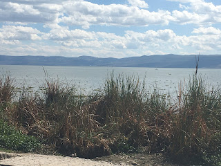
Lake Chapala is a BIG lake, the third largest in Latin America after Lake Titicaca in Peru and Argentina Lake in Argentina (?)

From the Malecon shore walk
The view at sunset from our abode
Another view from our balcony
The view from the top of a mountain close to the lake
You can see the beauty of the lake from the pictures in this posting, but we wanted to share some facts about it too.

(1) First — its size.  It’s big.  It is about 50 miles long from east to west and about 10-15 miles wide from north to south, thus covering about 420 square miles.  Oh, and its about 5000 feet above sea level.  Yes, that’s almost a mile up, and that’s about the same distance up as Denver, CO.  Oh, and it supplies 55% of the drinking water for Guadalajara.

(2) It’s a shallow lake, with a mean depth of 23 feet and a maximum of 34 feet.  Actually, around 2001-01, Guadalajara and other areas of the country were taking so much water from the lake that it started to go dry. The lake was at 15% capacity.   Panic ensued, and fortunately, they were able to get the lake back to about 60% capacity, which is where they expect it will remain.

(3) It is fed from four rivers (Rio Lerma, Rio Zulu, Rio Huaracha and Rio Duerno), and it’s drained by the Rio Grande de Santiago.  The water then flows NW into the Pacific Ocean.  Is it polluted?  Well, yes, but it’s getting better:  “The water entering the lake from the Lerma River is highly polluted with heavy metals and other toxic substances as a result of insufficient wastewater treatment by many industries.  Additionally, many of the towns around the lake release their sewage and waste water into the lake without treatment” (from globalnature.org).  However, recent studies indicate that the lake is in decent shape, with decent water quality (you can swim in it, but we haven’t seen anyone in the water in Ajijic) and you can eat the fish from the lake.

(4) The lake has three small islands: Isla de los Alacranes (visible from the town of Chapala), Isla Mezcala (the largest and one which we hope to visit later in our stay), and a small one called La Isla Menor.  Contributing to the overall beauty of the area is the mountains and sierras that surround the lake: five different ranges.

(5) And we can’t forget all the towns surrounding the lake, including Chapala (Ajijic — where we are staying), San Antonio Tlayacapan, Jocotepec, SAN Juan Cosala, San Luis Soyatlan, Mezcala de la Asunción, Tizapan, El Alto, La Palma, Michoacan, and Ocotlan.  We will be doing a tour around the lake toward the end of our stay here.  Actually, it was supposed to be last week, but Julie’s back injury meant we had to postpone the trip.   Grrr.

(6) The combined population of those towns around the lake is large, but I couldn’t find any reliable number of people. I did learn, however, that the cachement area for the lake has about 11 million people.   But the number of expats is around 30,000, but I have heard that at times there are 50000,  depending upon the time of year.

 You can see the fishermen, especially busy during the weekends.


Lots of birds by the lake.  There is a Lake Chapala Birders association which monitors the bird numbers and which is an active bird watching group.  They found 177 difference species of birds in the December of 2019 bird count, 40 more species than they found in December of 2018.

This is a huge nest of green parrots on the Malecon walkway

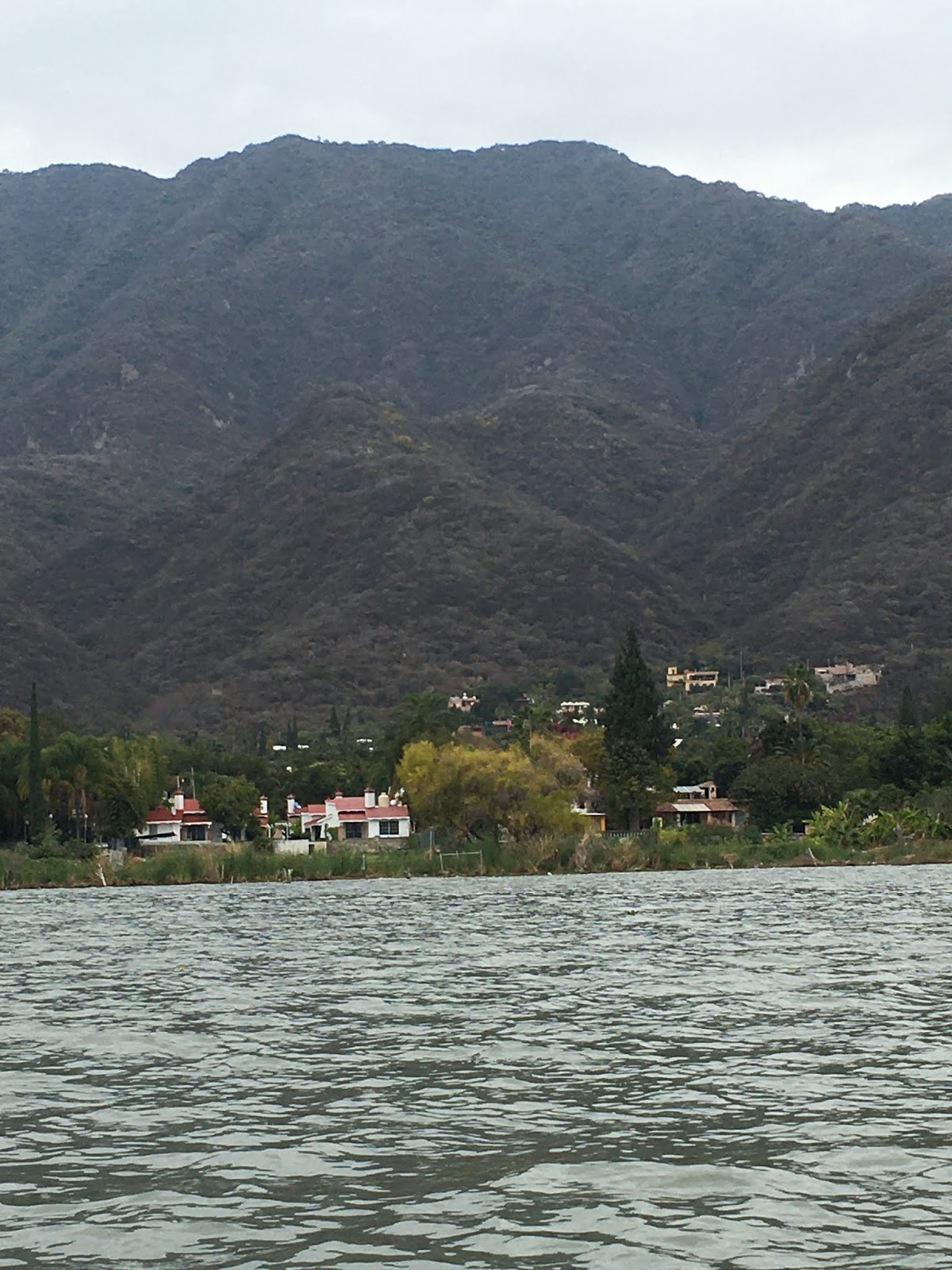
On one of our many walking treks on the Malecon, there was a boat for rent.  We decided to go for it, and here are a few shots of the shoreline and the mountains from the water.


Hard to see, but that is the view of the skateboard park along the Malecon.  It was getting heavy use on this day.

If you look at the Ajijic Hiking Group post, you will note that on our first hike, we hiked up to the chapel.  That little yellowish blob on the hillside is the chapel.  There is an up close picture on the Ajijic Hiking post.


This is apparently a hotel, according to our driver, who only spoke Spanish.  I suspect it is a resort because that green space appeared to be a golf course.

Hiking in Ajijic

Yesterday (January 28), we joined the Ajijic Hiking Group for a 2 hour hike.  This is an amazing group of people, dedicated to hiking and to others going along for the ride (so to speak).  Every week they hike on Tuesdays and Saturdays, beginning at 8:45 at a location not too far from our abode.  They set up multiple hikes each hiking day:  3 short hikes (usually about 2 to 2.5 hours), a couple of intermediate hikes (3 to 4 hours), and a couple of longer hikes (more than 5 hours).   Yes, lots of hikers!

We chose the shortest and easiest hike, but easy isn’t really an appropriate term.  The path was narrow and rocky and the climb was about 500 feet, not too bad, except that we are already at 5000 feet above sea level.  I was puffing, but the view was spectacular, especially from the top.  Our group had a leader and six people (including us): one from Cleveland, his granddaughter, a woman from DC, and two people from Canada (lots of Canadians in the overall group).

We talked about many things, including good restaurants, where people were living, how so many Americans came after the dot.com crash, how the Canadians started coming after that, and then when Trump was elected, there was another influx of Americans. . . .

Unfortunately, on the way down, I bent over to grab a tree branch to step down a particularly steep “step,” and I twisted my back.  I didn’t slip or do anything unusual, from what I could tell, but oh la la — what a backache.  For awhile I thought it might be a trip-ending injury.  I am doing a bit better today (meaning I can sort of walk around our house).  We’ll see how it goes tomorrow.  Damn.

But here are a few pictures from the hike, previous to the back issue.

Some of the large group when instructions were being given and people were deciding which hike to go on
Harold, getting ready to hike
Our group — the “chapel hike”
The way up
The chapel at the top
We made it!
We met this guy on the way down.  He was knocking some red bean-like things off a tree.  You open the pod and there are oval-shaped “peas” in the middle.  He gave us each one of them.  They were good, sort of like edamame.
All was good until my back twisted :-(.  Grrr.  Hiss.  We probably won’t be able to hike with them again. 

Orozco mural in Government Palace in Guadalajara

We had traced some of art and murals of both Diego Rivera and Jose Clemente Orozco on a previous trip to Mexico City (and even before then), so we were excited to see the Orozco murals done in Guadalajara.  When he painted these murals, he was quite elderly and could barely see, so it was hard to imagine how the painted them when his face had to be so close to the wall.  The paintings are immense and scale up both sides of a large stairwell with a curved ceiling.  It’s hard to imagine. . . .

The dominant image of this huge mural — entitled “The People and It’s Leader” — in the Government Palace is the white-haired Miguel Hidalgo brandishing a flaming torch which seems to move as you move from one side of the painting to the other.  His eyes also follow you.  Well, some people claimed his eyes followed the.  I couldn’t really see it myself. . . .  Hidalgo was the individual who ignited the independence movement in Mexico, so the symbolism of his brandishing the torch is not lost on viewers.  His intent seemed to be two-fold: to liberate the down-trodden from the forces of religion and politics.

The work is divided into five parts, moving from left to right as one views the mural from the top of the stairs: the dark forces, fratricidal struggles, Hidalgo, the victims, and the contemporary circus. 
This picture gives you a sense of the ceiling work as you descend the staircase. 

The view to the right — contemporary circus

This is the scene beneath Hidalgo — the victims
A second Orozco mural can be seen in the government palace.  It is again a scene with Hildago, but this time he has a pen in his hand and is signing the document giving independence to Mexico, but he is writing in red blood, signifying all who died during the struggle for independence. 
Orozco is made somewhat immortal because his statue appears in the Plaza de la Rotunda which includes statues of many of the heroes of Mexico and Jalisco, including people who distinguished themselves in arts, science, education, human rights, law, and politics.  Orozco’s statue is one of 24 statues.


Tlaquepaque — January 24


After our tour of the historic center of Guadalajara, we went to the artisan village of Tlaquepaque, a suburb of Guadalajara.  This community had three things that made it a delight:  wonderful restaurants, several with mariachi music; street musicians; and sidewalk shops and stores carrying the work of artisans from all over the country.  It is apparently the largest grouping of Mexican artisans in the country.

First things first — we headed to a restaurant.  The choice we made was Casa Luna.  It was a good food choice, but the atmosphere was as good as the food.  We were in an outdoor, open-ceilinged patio, and within the area, there were three huge “trees” made from pieces of wood.  Each tree was decorated differently, one with castanets, one with butterflies, and one with hearts (probably seasonal).


The food was good too.  We had a heart of romaine salad stuffed with avocado.  Delicious.  We both had the chicken poblano mole for our entree.  I’m not a big fan of mole in the US, and I guess I won’t order it again here, but it was tasty.
Yes, there’s a large chicken breast buried in that sauce.
The drinks were also special.  Someone at another table bought a drink that came in a glass bulb which was steaming like it was dry ice.  Then when the server took off the bulb, the steaming whatever it was was very fragrant and the smell wafted through the entire restaurant — smelled like marijuana.  There also was a group of volunteer workers at the next table, and the servers went from one person to the next with a long silver leaf which they pointed into the person’s mouth.  Then another server poured a bottled drink — probably tequila — into the leaf and it trickled into their mouths.  Great fun to watch them all.


After eating, we wandered and listened to some musicians.  The highlight was the famous Mariachi Women who became stars when they competed on the Mexican Has Talent show (like the ones we have in the US).  A female musician was upset because none of the mariachi bands, all male, would allow her in the band, so she started her own.  Now they are famous.  They played one song in the street before they headed into a restaurant where they are regulars.

Warming up

There were four dancers too
The entire area was filled with artisans and artisan shops and also lots of unique sculpture art along the way.  We saw the perfect mask that we should have bought but didn’t.  Now we may have to go back to buy it because according to Rosie, our guide, there isn’t another place like this in Jalisco.


All in all, it was a great day.


Guadalajara historical center tour — Jan 24

We took our first excursion today through at group called Charter Club, which turns out to be run by a group of ex-pat Canadians.  We were a group of ten, and all of the others were Canadian.  We were all sympatico on this one-day trip to Guadalajara and Tlaquepaque.

The day had some stress since we’ve been having trouble with our door locks (the second day we actually had to call the person in charge to come and open the door).  Well, that potential crisis passed.  Then I couldn’t figure out the taxi transportation quickly enough, so we had to walk the 1.4 miles to Black Coffee, our meeting point across from WalMart.  We trekked along rather quickly, and arrived within 30 minutes.  We met several ex-pat walkers along the way, and the walk turned out to be quite pleasant.

So we boarded our bus and off we went.  Rosie, our guide and our driver, was a wealth of information.  The major portion of our tour was spent in downtown Guadalajara, and this posting will focus on our tour there.  Another posting will focus on the mural art of Orozco and a third on our lunch and shopping in the artisan town of Tlaquepaque.

First, the tour of the historic Center of Guadalajara.  Our tour focused on our trek around the area that was designed in the shape of the cross.  You can’t tell that when you’re walking it, of course, but from above you can see the cross shape.  In the center of the cross is the Guadalajara Cathedral, and the three top shorter sides all have park areas with fountains, statues, and various governmental buildings.  The longer bottom section of the cross includes more parks and the foot of the cross is the old and majestic opera building. The back side of the opera building is a commemorative sculpture of the founding of Guadalajara in  1542.

First, the Guadalajara Cathedral, also called the Cathedral of the Assumption of Our Lady, is located in the center.  It has gone through many incarnations.  The first part of the present-day church was built in 1542.  Its many incarnations have been and still are being damaged by earthquakes, and currently, there is a slight tilt to the north tower and damage to the dome.  That said, it is a beautiful cathedral with gold leaf, silver, columns, stained glass windows, a German pipe organ — it’s all there.  Here are some pictures to give you a sense of the place.


Then, as mentioned before, the heart of the cross — the cathedral — is surrounded by several squares, each one specific in intent (like honouring heroes, etc.). Here are some pictures of those areas.
  Miguel Hildago is breaking chains from the Church and the elite.
As we approached the left part of the cross, we see the cupola in this area.


In the early times the women would go out every morning to cover the breasts of these female muses, all done in bronze.  Every evening workers would take off the “clothes.”  They painted the statues green, and thus they weren’t so lewd, and the covering stopped.  ?? 


We observed horse-led carriages - but this is the "horse-less" that we saw.
The opera house was beautiful.


The workman was cleaning up the statuary behind the opera house which signifies the birth of the nation in 1542.
Rose, our guide, talked about three things that are unfortunate in this large public area.  First, the area will never become a UNESCO Heritage Site because they have either torn down buildings and rebuilt them (in the style of ancient times, but not as replicas) or else they have covered the facades to make them look more modern.  She was very disappointed that the city was not paying more attention to the older buildings.  We are too.

Secondly, the effects of earthquakes can see seen.  During one of the earthquakes, a steeple on the cathedral fell, and they have had to be replaced.  The effects of earthquakes were visible when pointed out to us.

Thirdly, they have built an underground subway system under this entire area, and the area beneath the buildings is sinking :-(.  Thus, the buildings are sinking and tilting in some cases.  You could see several areas where they were trying to shore up the constructions.  Scary.

Here, the arches are being supported.
Note the wooden supports on the columns supporting the arches and the steeple.
The entire “historical” section of the city was beautiful, and it was delightful to see all the groups of school kids (all very well behaved), the workers, the tourists, and other visitors enjoying the areas.